Digital Landscape Traces: Mapping Locals and Tourists in Germany
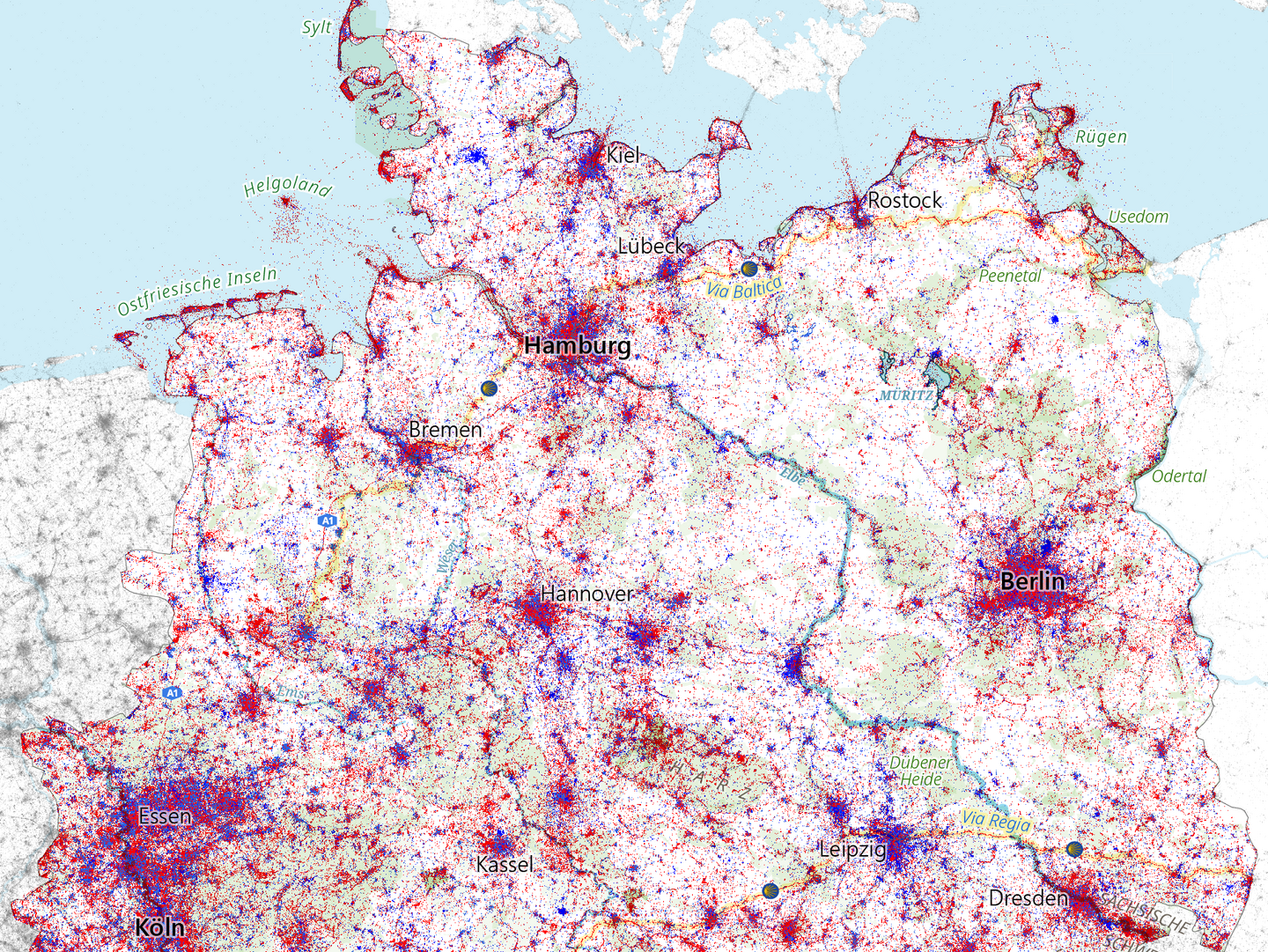
We just released a new map and the accompanying data pipeline titled “Digital Landscape Traces” (Digitale Spuren in der Landschaft). This work, published in the series Natur und Landschaft in Karten (NuL), visualizes over 66 million georeferenced social media posts across Germany from a 15-year period (2007–2022).
The core idea of this visualization was to distinguish between Locals (Blue) and Tourists (Red) to understand how digital attention manifests in physical space. While urban centers often show a mix of tourist hotspots surrounded by local activity rings, rural areas reveal distinct “islands” of tourist interest amidst broader local usage.
This project was a collaboration between the IOER and Prof. Catrin Schmidt (TU Dresden, Institute of Landscape Architecture). Beyond the map itself, a major focus was establishing a privacy-by-design workflow. We used probabilistic data structures (HyperLogLog) and spatial aggregation to ensure that we could analyze these massive datasets without compromising individual user privacy.
Processing Pipeline & Notebooks
The entire processing pipeline is documented and available online. We processed the raw data (which remains internal due to privacy constraints) into an anonymized, reproducible dataset using the following workflow:
- Overview: https://code.ad.ioer.info/digital_traces_map/
- Step 1: 00_user_origin_conversion.html
Preprocessing: Conversion of raw user-origin data. - Step 2: 01_clustering.html
User location classification: Inferring “Home” vs. “Tourist” status based on activity patterns. - Step 3: 02_parquet.html
Transformation: Converting the classified data into performant Parquet format for visualization. - Step 4: 03_visualization.html
Visualization: Generating the final high-resolution map using Datashader.
Source Code
The source code is maintained on GitLab (including CI/CD) with a mirror on GitHub for public discussion and issue tracking:
- GitLab (Source): https://gitlab.hrz.tu-chemnitz.de/ad/digital_traces_map
- GitHub (Mirror): https://github.com/ioer-dresden/digital_traces_map
Data Publication (Replication Package)
To ensure reproducibility, we published the aggregated, privacy-safe dataset used to render the final map via the ioerDATA repository.
Dunkel, A., & Nieswand, M. (2025). Replication Package for: Digital Landscape Traces - Locals and Tourists in Germany Map. Landschaft und Natur in Karten. – Naturschutz und Landschaftsplanung (NuL). DOI: 10.71830/VDmUWW
Article
The article explaining the context, interpretation, and relevance for spatial planning is published in Naturschutz und Landschaftsplanung.
Dunkel, A., Schmidt, C., Wende, W., Nieswand, M. (2025). Digitale Spuren in der Landschaft: Ein neuer Blick auf Deutschlands Naturräume durch Soziale Medien. Landschaft und Natur in Karten. – Naturschutz und Landschaftsplanung (NuL). DOI: 10.1399/NuL.190572
You can view the article (German) here: NuL Online Article
https://www.ioer.de/presse/aktuelles/digitale-spuren-in-der-landschaft